Showing posts with label Catskill hikes. Show all posts

Wednesday, April 29, 2015

Don't overlook Overlook!


Off and on all week, I had suggested to Bill that we go for a bike ride on Sunday.  I always think of biking during mud season, when hiking trails are muddy with remaining icy patches. To my surprise, when Saturday evening came,  Bill suggested we hike Overlook Mountain in Woodstock, New York, instead. Since the trail is an old carriage road, snow or mud conditions wouldn't be formidable.

(Yikes, a full parking lot!.)


 While Overlook truly does have a beautiful "overlook" and a fire tower with great views, the mountain's location, right in Woodstock, means that we can combine the hike with Joshua's, our favorite Middle Eastern restaurant.  At 5 miles round-trip with an elevation gain of 1400 feet, hiking Overlook, followed by dinner, makes a nice outing.


(As Bill had predicted, the path was nearly dry.)


In addition, we drive the scenic route to Woodstock, down Route 32, waxing nostalgic as we pass some old haunts along the way from our first year of marriage, when we lived in Acra, a village of 200 people. This drive takes a little longer than the thruway, but it's part of what makes the day a treat.


(Views through the trees abound before the leaves come out, and how about that mountain laurel?  We have never caught it here in bloom.)


Once in Woodstock, we drove up the road from the village, winding higher and higher, to where strings of prayer flags flew outside every house. Woodstock has been an artists' community since the Hudson River School painters came here in the 1800s.  That, combined with its attraction for folk and rock musicians since the 1960s, gives the town a funky vibe.


(Patches of snow remained as we got higher up.)

To our dismay, every parking spot was taken in the trailhead lot, and parking along the road is not allowed.  It had been a long cold winter.  Like us, other people were eager to get out on one of the first nice spring days.  We drove down the road, turned around, and came back.  A spot had opened and we made a run for it!  As with many places we visit, a parking lot can be full without making the location feel crowded.  Overlook can comfortably accommodate quite a few hikers and still be very pleasant. 


(Remains of the last Overlook Mountain House are completely overgrown)


It felt great to hike in just hiking boots,with solid ground underfoot, instead of hiking in snowshoes or using microspikes. With the air temperature around 60 degrees, and a cloudless sky, we couldn't ask for more.


("A view from the Piazza of Overlook Mountain House, 3000 feet above the sea")


Two miles up the carriage road are the remains of the Overlook Mountain House. Four different hotels had been built on this same location, beginning in 1833 and ending in 1941.  Unlike other Catskill hotels, Overlook's higher elevation, and lack of a direct railroad line, made the hotel difficult to access and a less-popular travel destination. During the century, each successive hotel fell to fire. Eventually, the mountain became the property of the State of New York, and the last of the hotel remains was abandoned.


(360 degree views of the Catskills and the Hudson Valley are spectacular from the fire tower )
The final half-mile of the hike, from the Mountain House to Overlook's summit, had about a 6-inch snow covering.  A strong sun and spring warmth turned the snow to mush, and our pace slowed.


Still, it didn't take long to pass the ranger's cabin, and reach the fire tower. I climbed the tower and admired the spectacular views  in all directions. The atmosphere had the clarity of winter, with the warmth of spring; I could see for miles.

Bill and I had hiked so many of the peaks in view. Since he grew up "on the mountaintop" in Prattsville, my first visits to his parents' home often included hikes.  And when we lived in Acra, we explored the entire region with friends and cousins. Over the decades, we often returned to favorite places.


(The Mountain House remains in the foreground, a sliver of the Ashokan Reservoir in the center, and the Burroughs Range still snow-covered as the backdrop)

Bill is not a fan of fire towers.  That's okay, because Overlook has rock ledges that offer excellent views of the surrounding mountains and the Hudson Valley. A small sign by the ranger's cabin indicates a narrow path, leading to a scenic viewpoint.


(The Blackhead Range from the fire tower)


We sat on the rock ledge, soaking in the sun and the view.  I had packed nut bars and apples for us.  These would hold us for now.

Nineteenth century tourists often carved their names and a date into the slate ledges. The date of 1859, in this photo, was the oldest we found here.We could imagine women in long dresses, and men  with bow ties, walking up from the hotel for a light picnic on this rock.


Although, today, carving in the rock is discouraged, we found that recent hikers still sometimes etch their names in stone.
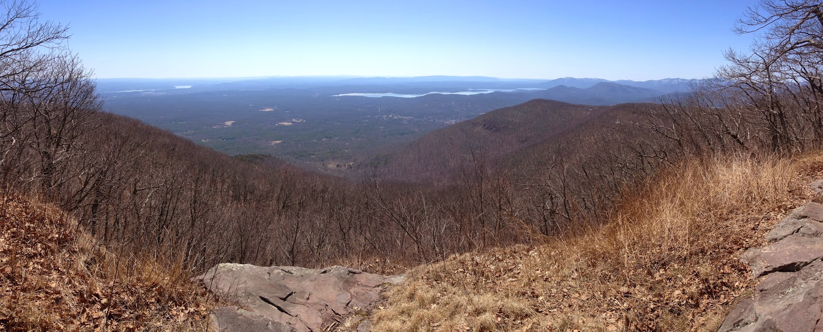


(a panorama from a rock ledge looking east to the Hudson River)


Instead of returning on the old carriage road for the first half-mile of our descent, we chose to stay on the trail that continues along the edge of the ridge past numerous viewpoints.  To our surprise, this trail had had just enough sun to melt the last of the snow.  Walking was easy and pleasant, not slippery with slush.


(the ridge trail is dry and walkable)

Returning to the trailhead, we signed the log book, and left a parking spot for other eager hikers.  We had more on our agenda for this gorgeous spring day.

Parking was easy in town, although plenty of people were here too, sitting on benches, eating ice cream cones, or playing guitars on the square.  We hadn't been to Woodstock in five years, a long time away for us.  As we walked the village streets, we discussed what businesses had left, or moved. We don't go in many of the shops, but we do have a few favorites. Fortunately, Joshua's is a mainstay.


(Joshua's, an old favorite, and still delicious)

Isn't it great to go to a place you love and still find many of the same dishes on the menu that you remember?  Today, I had the Shwarma salad, a delicious house salad with tomato, avocado, brown rice, grilled chicken (or tofu), and a cucumber feta dressing. The refreshing flavor of cucumber in the salad dressing complemented the salad perfectly.  Bill had the smorgasbord of stuffed grape leaves, felafel, tabouli, hummus, baba ganoush, olives, and an Israeli salad.

(shops vary from expensive boutiques, to places with embroidered or tie-dyed clothing, Birkenstocks, and books)

After dinner, we walked from one end of town to the other.  And then we drove home, back north through the countryside. It had been a day to savor.

Wednesday, May 29, 2013

In the Catskills with Mr. Map-man


Some of my regular readers will remember my post "Catskill Ramblings," from June 2011,when Bill and I attempted to hike the paths of the Hudson River School painters, places we had been to decades before.  That day the fog had been so thick that we could barely see the edge of the rock.  A couple of weeks ago, we decided to make a return trip.

Parking at the trailhead on Schutt Road, near North Lake in Haines Falls, we had a perfect, clear, mid-Spring day. As we signed in at the kiosk, we were confronted by a nice couple who were vacationing in the Catskills for a few days.  They were confused about where they were and where they wanted to be, pulling out directions that they had printed off their computer before they left their Pennsylvania home. Map in hand, Bill did the best he could to point them in the right direction for the hike they hoped to do.

(Bill checks the map in front of the Layman monument)
Even though we had been to this area before, and Bill grew up very near here, he had researched every road and trail before we came and had his map collection with him.  Studying the maps is part of the fun.

We were headed for the famous Escarpment Trail and some of its most picturesque locations.  Our first stop was the Layman monument, built to honor Frank Layman who died in 1900 fighting a forest fire here. Frank could have been one of Bill's family members, Layman was his grandmother's maiden name. When I first met Bill, it seemed like everyone, alive or dead, was related to us in some way.

(one of many views along the Escarpment above Palenville Pass)

Rock cliffs abound along the Escarpment and offer 180 degree views.  No wonder many wealthy resorts were built here such as the Laurel House, Kaaterskill House, and the huge Catskill Mountain House.  Most of them succumbed to fire long ago, but evidence that people enjoyed this area at that time is still here.

We could still read some of the names etched into the rock.  C.W. Morris did a good job of giving his name a permanent place when he came in 1916, and then again in 1917 and 1923.  Was C.W. a young man, who, between 1917 and 1923, went off to France during World War I?  Perhaps, in 1923,  he returned to this overlook with his sweetheart.

(C.W. Morris, 1916-17-23)

As we hiked along the narrow path, passing wild blueberry bushes in bloom, I suddenly smelled spices, and heard a sizzling sound.  In minutes, we arrived at the point where the narrow path opened to the wide ledge of Inspiration Point.  So close to the path that we literally had to step around them, about a dozen Chinese people were crouched on the rock cooking a full course meal!

One man stirred a wok over a flame, quickly tossing meat, the source of the sizzling sound and the smell.  A woman took noodles out of a large container.  Each participant sat on a short collapsible stool with containers of food, plates, glasses, and utensils laid out on a large blanket.  This was one luxurious, albeit highly illegal, picnic. We continued walking along the rock as they delved into their feast.


(A multi-generational family having a feast on the ridge)


Farther along, Bill and I found a spot to sit and eat our peanut butter and jelly sandwiches, and apples.  Inspiration Point is large enough for all of us.

(Bill on Inspiration Point)


As we continued on, I couldn't help but compare this area to the Adirondacks. Whereas northern trails consist of black dirt from decayed hemlock and balsam needles, and the rocky paths seem not much different from stream beds, the Catskills have red earth with flat shale rock. Walking on this trail of naturally crushed stone between hardwood trees just coming into leaf, I could imagine Thomas Cole, the founder of the Hudson River School of painting, hiking here with his flute and his sketch pad.


(parts of the Escarpment trail are very inviting)

I got ahead of Bill for a while, as we became mixed in with two couples and three dogs.  One man stepped back to ask Bill, "Do you have a map? We're hoping we can find a trail to the parking area without having to walk all the way to North Lake."  Bill pulled out his map and they discussed options. I heard one of the women ahead of me, say, "Oh yeah, Pete doesn't know where we are, Mr. I-know-everything-about-the-Catskills!  It's good he found that man with the map."  Apparently, Pete's guidance had worn a little thin.


(Eventually, we reached views to the Hudson Valley in the East)
I kept hiking, dodging the dogs, ages 15, 11, and 5.  The 15-year-old kept his head down but trudged on.  At the intersection, posted with a nice array of DEC trail signs, we stopped to wait for Bill and Pete.  "I hope Pete is learning something from Mr. Map-man," the woman said.

When Pete and "Mr. Map-man" arrived, the signs gave them new fodder for map study.  Bill told the others which trail they should take, and then he and I continued on our way.  This group was from New Jersey, and they did not even have internet directions like the Pennsylvania couple we had met earlier in the day.  I was surprised that so many people would hike without maps.


(Mr. Map-man saves the day)


Our final destination before heading back was Boulder Rock, left by long ago glaciers.  Once again the ridge offered views across the valley.  We returned on a different trail making a nice loop of about 6.5 miles total.


(Boulder Rock)

As we neared the parking lot, we saw the Chinese family just ahead, jovial and chatty after their feast. The men carried full-sized backpacks with their kitchen gear and whatever food was left, as well as all of the individual stools they had sat on.  The women carried nothing.  Both men and women appeared to be experienced hikers, equipped with proper clothes, boots, and trekking poles.  At the parking lot, they climbed into a 15-person van and drove off.

Before completely leaving the area, we decided to walk to the top of Kaaterskill Falls.  Kaaterskill Falls is generally seen from its base, a half-mile walk in from Route 23A in Palenville Pass. Here at the top, a short trail leads to its rocky ledge where water drops 260 feet. This is not for the faint of heart; in the course of a summer, it is not unusual to read about someone falling to their death on one of the trail-less areas alongside this cataract.


( Water tumbles over Kaaterskill Falls, with tiny people on the path below)

A group of Asian students offered me a spot on the rock where they were sitting. Bill, a bit leery of heights, stayed back. Not only was it fascinating to watch the water cascade over the rocks, but I loved seeing people far below who were hiking into the base from the road. After I took a couple of pictures, Bill and I walked upstream along the creek and past the foundation of the Laurel House, within sight of the top of the falls.

We ended our afternoon, with a stop at the nearby camp store for a Perry's ice cream cone. At home, Bill perused his maps, comparing them to the book description.  Then Mr. Map-man put the book and maps away.  We probably wouldn't hike in the Catskills again until later in the year, when the tourists left and chilly weather returned.